1856 PLAT MAP PICTURES
FAYETTE COUNTY, INDIANA
Pictures taken May 7, 1998
| Back to home page | Partial index of owners |
Click on a section number to view a portion of the map that contains your selection.
Bold section numbers are the top left of each map picture.
You can print, or save the picture to a file (right click & Save Image).
You can also use a photo editor tool to enlarge/crop/join images as desired.
Click here
for information about image size and resolution.
| POSE 3 |
Y n/a 2 |
n/a 1 |
n/a 6 |
n/a 5 |
n/a 4 |
Upper right corner of 1856 map: Town of Connersville (located at ## below) North half South half |
|||||||
| 10 |
11 |
12 |
7 |
8 |
9 |
||||||||
| 15 |
14 |
13 |
18 |
17 |
16 |
||||||||
| 22 |
23 |
24 |
19 |
20 |
21 |
||||||||
| 27 |
26 |
25 |
30 |
29 |
28 |
||||||||
| FAIR 34 |
VIEW 35 |
36 |
HARR 31 |
ISON 32 |
33 |
34 |
35 |
36 |
31 |
WATE 32 |
RLOO 33 |
34 |
35 |
| 3 |
2 |
1 |
6 |
5 |
4 |
3 |
2 |
1 |
6 |
5 |
4 |
3 |
2 |
| 10 |
11 |
12 |
7 |
8 |
9 |
10 |
11 |
12 |
7 |
8 |
9 |
10 |
11 |
| 15 |
14 |
13 |
18 |
17 |
16 |
15 |
14 |
13 |
18 |
17 |
16 |
15 |
14 |
| 22 |
23 |
24 |
CONN 19 |
ERSV 20 |
ILLE 21 |
22 |
23 |
24 |
19 |
20 |
JENN 21 |
INGS 22 |
23 |
| 27 |
26 |
25 |
30 |
29 |
28 |
27 |
26 |
## 25 |
30 |
29 |
28 |
27 |
26 |
| ORAN 34 |
GE 35 |
36 |
31 |
32 |
33 |
34 |
35 |
36 |
31 |
32 |
33 |
34 |
35 |
| 3 |
2 |
1 |
6 |
5 |
4 |
3 |
2 |
1 |
6 |
5 |
4 |
3 |
2 |
| 10 |
11 |
12 |
COLU 7 |
MBIA 8 |
9 |
10 |
11 |
JACK 12 |
SON 7 |
8 |
9 |
10 |
11 |
| 15 |
14 |
13 |
18 |
17 |
16 |
15 |
14 |
13 |
18 |
17 |
16 |
15 |
14 |
| 22 |
23 |
24 |
19 |
20 |
21 |
22 |
23 |
24 |
19 |
20 |
21 |
22 |
23 |
| 27 |
26 |
25 |
30 |
29 |
28 |
27 |
26 |
25 |
30 |
29 |
28 |
27 |
26 |
| 34 |
35 |
36 |
31 |
32 |
33 |
34 |
35 |
36 |
31 |
32 |
33 |
34 |
35 |
As of this writing, the map is hanging in the main hallway
of the Fayette County courthouse in Connersville, Indiana.
TECHNICAL DETAILS:
Photos were taken by Jim Hartsell of Sunnyvale, California, using rig shown below.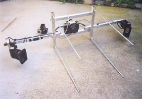
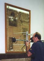
Photographs were taken May 7, 1998.
Map at courthouse could be darker now due to exposure to light.
Photographs were taken on 100-speed 35 mm Kodak print film.
Dual flash was used, angled from left and right.
A gray card was photographed for printing calibration.
Area of original photographs is approx. 4 by 6 sections.
All photographs were from the same distance, but 8x12 enlargements vary.
An HP 5200Cse scanner was used to scan 8x12 enlargements.
Adobe Photoshop was used to enhance brightness and sharpness of image.
Images were saved in Adobe Photoshop JPEG High resolution format.
Image size is approximately 600 x 800 pixels for a 3 x 4 section image.
When printed from a web page, resolution is 96 ppi and print size is about 6" W x 8.5" H for a 3 x 4 section image.
When saved as a file, and printed from a photo editor, resolution is 150 ppi and print size is about 4" W x 5.5" H for a 3 x 4 section image.
Files size is approximately 200 KB for a 3 x 4 section image.
| This work is being done as a labor of love in gratitude for this map being there. I have 5 pairs of ancestors across 3 generations who lived in NE Fayette county 1815-1860. This map is an incredible stroke of luck for me. It is a snapshot in time, and shows the roads that existed then, towns, churches, streams, neighbors, etc. Using the 1850 Census, and following the census taker's route against the names on the 1856 map, I could find where people lived even when they didn't own land. I could even find the names of the kids my greatgrandparents knew when they were kids. How else could you do all this! |
![]()
![]()