|
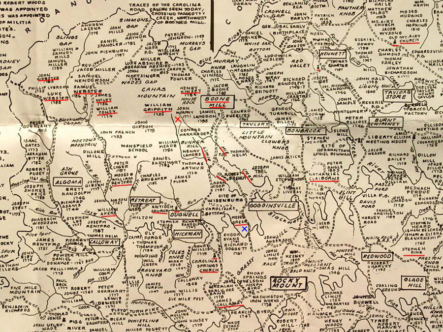
Hartzell land & locations, Franklin County, VA, 1792-1818 Philip Hartzell's 1792 land purchase, 1797 land sale, etc. By James Dwight Hartsell, Dec. 18, 2004; updated Oct. 14, 2006 Print in landscape mode with all margins = 1.0". Back to home page Underlined on map below: |
||
|
WILLIAM TONEY: Presumed grandfather of Susannah Toney (m. George Hartzell 1809). JOHN WEBSTER, SR.: 7 households before Adam Hartzell in 1810 Census. (John Webster Jr. was 3 households before Adam in 1810 Census.) Also nearby in 1810 Census were Luke and Samuel Webster. PHILLIP LYBROOK: (Below John Webster) Phillip's daughter Sarah married James Toney (grandson of William Toney) in 1820 in Union County, Indiana, where George & Susannah (Toney) Hartzell lived. JAMES McVEY: 2 households after Adam Hartzell in 1810 Census. 6 households before George (& Susannah) Hartzell in 1810 Census. WILLIAM GRIFFITH: "George Griffith's line" in Philip's 1792 land document MILL CREEK, LITTLE CREEK: Philip Hartzell's 1792 land purchase was around here, probably near the beginning of Little Creek & over to Mill Creek WILLIAM AKERS: 3 households after George Hartzell in 1810 Census. Witness for Adam's son Jacob's will in 1837. BOONE MILL: Adam Hartzell's sister Elizabeth's daughter Clarisy Kinsey married Isaac Boone in 1817. Isaac bought the mill from Jacob and Daniel Boone, and lived at the mill. Jacob Boone's name is just above Boone Mill. See archiver.rootweb.com/th/read/HARTSELL/1998-10/0909435616. Also see HENRY KINSEY. |
HENRY KINSEY: Proabably related to Jacob Kinsey/Kinzie who married Adam Hartzell's sister Elizabeth Sept. 11, 1798. Henry's wife's name was Eve. An 1804 deed mentions "a branch of Little Creek". Jacob's parents seems to have been Johannes and Chloe Kinsey. MOSES RENTFRO: Grandfather of Moses who married Adam Hartzell's daughter Elizabeth 1818 Ohio. William was Moses' father. NATHANIEL CLAIBORNE: Witness to Abraham Hartzell 1839 will, Franklin County VA. Member of Congress. MOSES GREER: Witness to recording of Philip's 1792 land purchase. His land was adjacent to Abraham Hartzell's 1796 land purchase. Moses Greer Jr. was county recorder in 1818. JAMES CALLAWAY: County recorder for Philip's 1792 land purchase; his heirs sold land to Adam's son Jacob in 1818, land bordered by George Hartzell's, Toney's, and John Webster's land. This George is probably the one who married Nancy Goode in 1823. STEPHEN SINK: Probable brother of Christina Sink who married Adam Hartzell. See www-personal.umich.edu/~cgaunt/etc/Sink0416.txt CHURCHES MARKED: Possible churches attended - Antioch Church at Dugwell? |
|
|
Width of map is about 20 miles. Click here for a pop-up USGS map of the area of Philip Hartzell's land, contributed by Paul Swan. On the USGS map, note the scale from Boone Mill to Dugwell is about twice the scale of the map below. 
|
Philip Hartzell's 1792 land purchase:NOTE: 150 acres is about 1/3 the size of the rectangle for Boone Mill, and if square, almost 1/2 mile on a side (almost a quarter section). Since the land touched or crossed both Little Creek and Mill Creek, it had to be where the creeks were about half a mile apart at that time. It was also adjoining George Griffith's land, and a William Griffith is shown on the map. According to a USGS map, the branch of creek south of Bunker Hill was part of Little Creek. The branch to the left of the name Conrad Harkrader could be Fox Branch. I would say the land was at the red X, just southwest of Boone Mill, and 8 or 9 miles NNW of Rocky Mount. "This Indenture made this Sixth day of February, one thousand Seven hundred & ninety two between Daniel Dillman of the County of Franklin of the one part and Phillip Hartzell of the same County of the other part Witness that he the said Daniel Dilman for and in Consideration of Sum of One Hundred & Sixty pounds Current money of Virginia to him in hand paid by the he(?) the Said Phillip Hartzell the Receipt(?) where of the said Daniel Dillman doth hereby acknowledge hath granted and Sold and by this presents doth grant Bargain and sell, Deliver & Confirm unto him the said Phillip Hartzel his heirs and assigns for ever one Certain(?) Tract or parcel of land containing one hundred fifty acres more or less lying and being on the Mill Creek, and bounded as follows to wit. Beginning at a poplar tree on a Branch which is called Fox Branch, thence down the same (branch) to a poplar Corner tree, thence to a Corner white oak then in bound by Spencer's old line on the south side of Little Creek to a corner Black Oak, from thence to a Corner Black Oak from thence continuing George Griffith's line thence bounded by Jacob Dilman's line & from thence William Spencer's new line agreement to Corner white oak from thence continuing the old line to a Chestnut tree on the east side of the Mill Creek from thence with the said line to a white Oak on the top of the hill North following the same Old line to pointer, from thence with it to a Black Oak on North side of (Fox?) Branch from there to first Station." ... Witnesses: Moses Greer, Chattin? Pollard?, Moses Greer Jr.
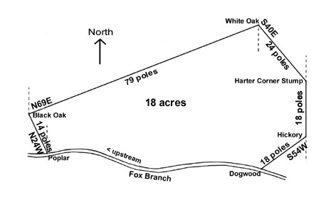
In the odd shapes of land shown below, it is not hard to believe when you look at a topological or satellite view and see how hilly and mountainous this area is. Philip Hartzell's 1797 land SALE:Some parts of the metes & bounds land description is hard to read, but by checking letters and numbers against other parts of the document, and making sure it comes out to about 18 acres, my estimation is below. Not knowing the path of the stream, I used basic geometry to work backward from the Harter Corner Stump to the upstream Poplar tree. Then I drew in the stream.
... a parcel of land lying and being in Franklin County on Fox Branch a Branch of
Mill Creek and bounded thus beginning at the said Harter Corner Stump,
Notice that Fox Branch flows nearly West to East, more or less, depending on the accuracy of my drawing. Being a branch of Mill Creek, it presumably flowed into Mill Creek on the right (East). Therefore, this land was west of Mill Creek, and presumably east of Little Creek. This land sale should give some clues on the location of Philip's 1792 land purchase. Philip's 1792 purchase BEGAN at a Poplar tree on Fox Branch, then went DOWN the branch. It ended at a Black Oak on the north side of Fox Branch, and from there to the first station (the Poplar on Fox Branch). These two points are on the left in the drawing above for the 1797 sale. The 1792 land description, agonizingly devoid of any compass bearings or distances, goes counter-clockwise. It goes along Spencer's old line on the south side of Little Creek, along George Griffith's line, then Jacob Dilman's line, then William Spencer's new line, then to the east side of Mill Creek, to the top of a hill north, and back to the beginning. I think the land sold in 1797 was a piece on the north of Philip's 1792 land. This implies that Philip's 1792 land included a stretch of Fox Branch, Little Creek, and Mill Creek. I am currently looking for the location of Fox Branch. Abraham Hartzell's 1796 land purchase:
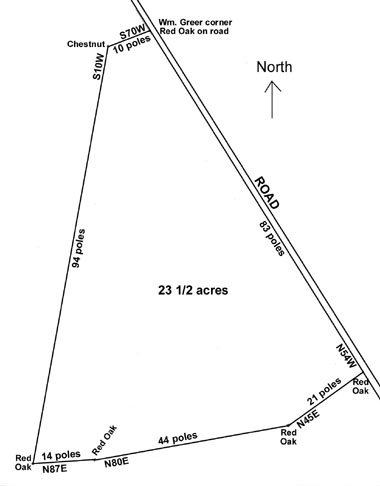
From Wm. Greer Corner Red Oak on the Road,
Here I drew the road last, and it came out at North 30 West, not North 54 West as specified
in the land record. Again, the beginning and end of a metes and bounds description don't
usually meet. I will try to redraw, but in the meantime it's not that important. A rough
estimation of the area of this drawing comes out to about 20 acres, so that's fairly close.
All we need for this one is a general idea of the shape and location of the land.
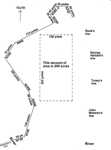
Jacob Hartzell's (m. Hannah Capper 1816) 1818 land purchase:
Beginning at a White Oak on the River (Blackwater River?),
DRAWING BELOW NOT TO SCALE OF ABOVE DRAWINGS
Many thanks to my brother Robert Hartsell and his wife Lynne for finding the land records and Settlement Map at Rocky Mount, Virginia in 1986, long before we knew this was our family. This entire web page is due to the information they found at Rocky Mount. |


