By Jim Hartsell, April 30, 2001
If you are seeing this as a printed copy, the latest is at www.jdhartsell.com, "1856 Connersville".
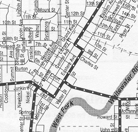
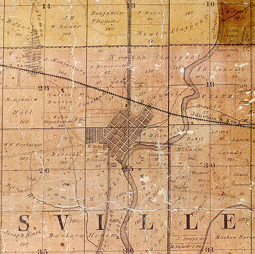
Below is the central part of 1856 Connersville, from the 1856 plat map in the hallway of the Fayette County Courthouse in Connersville. Following is a larger view of the town, then a 3-square mile view of the area surrounding Connersville in 1856.
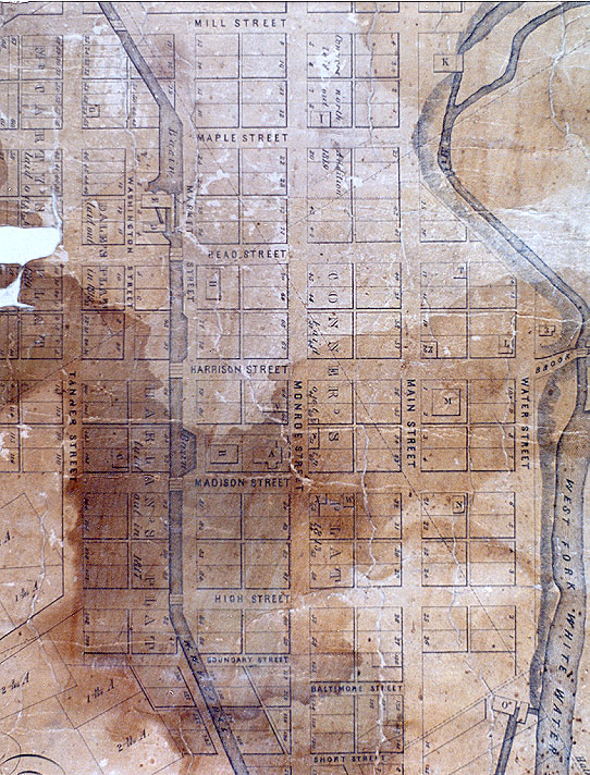
First map:
Top is northeast, but this page will simply say "north" for simplicity.
The map shows the canal, courthouse, banks, churches, mills, and factories but
not newpaper offices, blacksmith shops, stores, livery stables, etc.
There were also many private homes in town.
The White Water Valley Canal goes along Market Street and you can see the
bridges going over it, along with a lock towards the top.
The canal is now a railroad.
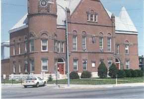
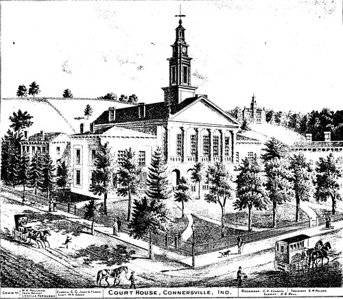
We begin at the Courthouse (A) at Madison & Monroe on the map (4th and Central now). A photo is shown below on the left. Behind the courthouse (west) in the same block on Madison was the Town Hall (B). Continuing west on Madison, in the middle of the next block was the Presbyterian Church (C). North of the courthouse in the same block on Monroe was the Fayette County Bank (V).
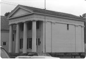
Across the street from the Courthouse on Monroe just south of the middle of the block was the Bates House (Y), then just north of the middle of the block the Bank Of Connersville (U). Diagonally across the street from the Courthouse, at the corner of Madison & Monroe was the Mansion House (X). East of the Mansion House, almost to the middle of the block was the Savings Bank (W) (1854-1856). From 1842 to 1854 this was the Canal House, headquarters for the Whitewater Valley Canal Company. It is now owned by Historic Connersville, Inc. at 411 4th St. A photo is shown below on the right.
|
|
In the next block east, just west of the middle of the block on Madison between Main & Water was the Methodist E. Church (N).
In the next block north of the Methodist Church, at the corner of Main & Harrison, was the Seminary (M). Across the street from the Seminary, at the corner of Harrison & Main, was the Gantt House (Z). In the eastern corner of this block, at Harrison & Water, was the Christian Church (L). Across Water Street, and a little north, was the African Church (3). In the same block as the Gantt House and Christian Church, on the north side on Head Street, was the Episcopal Church (T).
About one and a half blocks north of the Episcopal Church, on a river channel, was Conwell's River Mills (K). East of here, at the SW corner of the block, at Maple & Monroe, was the 2nd Presbyterian Church (I).
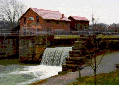
Two blocks west, at Tanner & Maple, was the West M.E. Church (G). Going down the canal, on alley-like Washington Street, was the Fayette Mills (E), and the Woolen Mill (D). These mills probably looked something like the mill in the photo below taken in Metamora, along with the water wheel that provided the power. The water wheel is in a side channel of the canal.
 |
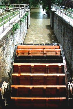 |
Photos from the Metamora web page. For more pictures of Metamora, go to www.metamoraindiana.com |
Diagonal across the intersection of Market & Head was the Market House (H).
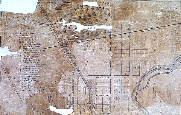
In the bottom right of the map, near the river, was the Connersville Mills (O).
Second map:
In the lower right below the Connersville Mills (O) was the
Connersville Iron Foundry (P). Below and to the left is what looks like a "Q"
for Conwell's Pork House, but it looks more like a lot than a building.
On the top right towards the right side and on the river was Conwell's Saw
Mill (J). A. B. Conwell owned a lot of land surrounding Connersville.
Two blocks north of Main and Mill was the Washington Foundry & Machine Shop (R), at what is now Eastern & 10th Street. A little north in the same block was the Catholic Church. The area at the top showing trees was the Park and Fairground. Just south of the park was the Junction Railroad. At the top left, on the river, was the Turning & Wagon Factory (1) and the Saw Mill (2).
The Steam Planing Mills (F) has not been located on the map.
Below is a drawing of the courthouse in 1849, taken from the 1875 edition of "An Illustrated Historical Atlas of Fayette County Indiana" by Higgins Belden & Co. of Chicago.
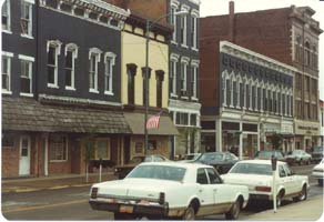
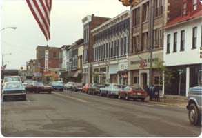
Below are two views of the same block in Connersville as it appears today, across the street from the Court House. The Connersville News-Examiner at the far end in the left photo is in a building dated 1849. In the right photo it is in the foreground, just past the white building. It is not shown on the 1856 map.
|
|
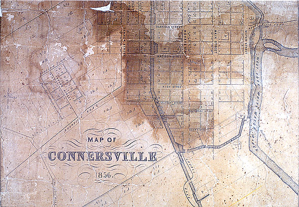
Roads out of town (second & third maps):
At the top left, the road paralleling the canal was
called the Connersville & Milton Turnpike, now Route 1, to Cambridge City.
This is the direction of North on the map. Off the picture, about 2 blocks
north on the Turnpike is the Cemetery.
On the right, midway down the picture, is Brookville Road, now Route 44 east,
to Liberty.
At the bottom, from Monroe Street, is Laurel Road, now route 121, to Metamora.
Along this road is Elmhurst, a large white building built in 1831.
At bottom left, from Tanner & High street, is Rushville Road, now Route 44
west, to Rushville.
| CODE | STRUCTURE | TODAY'S STREETS | 1856 STREETS |
|---|---|---|---|
| A | Court House | 4th & Central | Madison & Monroe |
| B | Town Hall | 4th & Grand | Madison & Market |
| C | Presbyterian Church | 4th between Western & Grand | Madison between Tanner & Market |
| D | Woolen Mill | Washington between 6th & 7th | Washington between Maple & Head |
| E | Fayette Mills | Washington between 6th & 7th | Washington between Maple & Head |
| F | Steam Planing Mills | ? | |
| G | West M.E. Church | 7th & Western | Maple & Tanner |
| H | Market House | 6th between Grand & Central | Head between Market & Monroe |
| I | 2nd Presbyterian Church | 7th & Central | Maple & Monroe |
| J | Conwell's Saw Mill | 2 blks NE "K" River Mills | ditto |
| K | Conwell's River Mills | Eastern between 7th & 8th | Main between Maple & Mill |
| L | Christian Church | 5th & Water | Harrison & Water |
| M | Seminary | 5th & Eastern | Harrison & Main |
| N | Methodist E. Church | 4th between Eastern & Water | Madison between Main & Water |
| O | Connersville Mills | 2nd & Water | Baltimore & Water |
| P | Connersville Iron Foundry | where Water & 2nd would be |
|
| Q | Conwell's Pork House | south of town? | S of town on Laurel Road? |
| R | Washington Foundry & Machine Shop | Eastern & 10th | north of town |
| S | Catholic Church | Eastern between 10th & 11th | north of town |
| T | Episcopal Church | 6th between Eastern & Water | Head between Main & Water |
| U | Bank of Connersville | Central between 4th & 5th | Monroe between Madison & Harrison |
| V | Fayette County Bank | Central between 4th & 5th | Monore between Madison & Harrison |
| W | Savings Bank, 1854-1856 (Canal House 1842-1854) |
411 4th St. | Madison between Monroe & Main |
| X | Mansion House | 4th & Central | Madison & Monroe |
| Y | Bates House | Central between 4th & 5th | Monroe between Madison & Harrison |
| Z | Gantt House | 5th & Eastern | Harrison & Main |
| 1 | Turning & Wagon Factory | N. of town, W. of Park | |
| 2 | Saw Mill | N. of town, W. of Park | |
| 3 | African Church | Brookville Rd & Water |
| 1856 | NOW |
|---|---|
| Mill | 8th |
| Maple | 7th |
| Head | 6th |
| Harrison | 5th |
| Madison | 4th |
| High | 3rd |
| Baltimore | 2nd |
| Short | 1st |
| Tanner | Western |
| Market (along canal) | Grand (along RR track) |
| Monroe | Central |
| Main | Eastern |
| Water | (same) |
Road going north is Route 1 to Cambridge City.
Road going east is Route 44 to Liberty; branch going south from 44 is Route 1 to Brookville.
Road going south, west of the river, is Route 121 to Metamora.
Road going west is Route 44 to Rushville.
